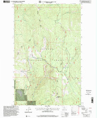
1997 Map of Pink Mountain
USGS Topo · Published 2000About this map
Baldy Mountain Lookout stands as a prominent high point in this 1990s revision of the northwestern Montana landscape. The map detail is dominated by the complex drainage systems of the Kootenai National Forest, where steep ridgelines separate numerous waterways such as Pipe Creek, Big Creek, and Deception Creek. This era of the Forest Service’s management is recorded through the administrative boundaries of the Rexford, Three Rivers, and Libby ranger districts, which converge within these mountains. Named peaks like Pink Mountain and a network of forestry roads and trails illustrate the geographic character of Lincoln County before modern digital mapping. The presence of Bearfire Creek and Beulah Creek flowing through these timbered slopes reflects the vital watershed role of the region's protected federal lands.
Find a feature on this map
27 named features on this map. Tap any name to fly to it.
Don’t see what you’re looking for? This feature index may not catch every label — zoom into the map to look around manually.
Map Details
Editions of this 1997 Pink Mountain Map
This is the sole edition of this map. No revisions or reprints were ever made.
Other maps of this area

1957 · Kalispell
USGS Topo · 1:250,000

1960 · Kalispell
USGS Topo · 1:250,000

1961 · Kalispell
USGS Topo · 1:250,000

1963 · Yaak
USGS Topo · 1:24,000

1963 · Turner Mountain
USGS Topo · 1:24,000

1963 · Pink Mountain
USGS Topo · 1:24,000

1963 · Banfield Mountain
USGS Topo · 1:24,000

1963 · Boulder Lakes
USGS Topo · 1:24,000
1963 · Flatiron Mountain
USGS Topo · 1:24,000

1963 · Lost Horse Mountain
USGS Topo · 1:24,000