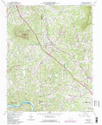
1964 Map of Pinnacle
USGS Topo · Published 1987About this map
Pilot Mountain and the surrounding Pilot Mountain State Park dominate the western landscape of this mid-century survey, which captures the intersection of three North Carolina counties. The rugged terrain of Sauratown Mountain to the east frames a valley defined by the Little Yadkin River and the Yadkin River. Human settlement is concentrated along the Southern railway line, where the community of Pinnacle serves as a local hub. The map reveals a deeply rooted rural community, documented through numerous country churches like Mt Moriah Ch and family burial sites such as Stone Cem and Wall Cem. Purple photorevised updates from the early 1980s highlight changes in woodland cover and infrastructure, including the Rest Area and expanded local roads, while the original 1964 data preserves the footprint of institutions like Pinnacle Sch.
Find a feature on this map
40 named features on this map. Tap any name to fly to it.
Don’t see what you’re looking for? This feature index may not catch every label — zoom into the map to look around manually.
Map Details
Editions of this 1964 Pinnacle Map
4 editions found
Other maps of this area

1891 · Yadkinville
USGS Topo · 1:125,000

1893 · Yadkinville
USGS Topo · 1:125,000

1951 · Rural Hall
USGS Topo · 1:24,000

1953 · Winston-Salem
USGS Topo · 1:250,000

1955 · Winston-Salem
USGS Topo · 1:250,000

1962 · Winston-Salem
USGS Topo · 1:250,000

1964 · Hanging Rock
USGS Topo · 1:24,000

1964 · Pinnacle
USGS Topo · 1:24,000

1964 · King
USGS Topo · 1:24,000

1964 · Pilot Mountain
USGS Topo · 1:24,000