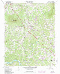
1964 Map of Pinnacle
USGS Topo · Published 1987About this map
Pilot Mountain State Park anchors this landscape, where the unmistakable knob of Pilot Mountain rises near the Southern railway line. This 1964 survey, revised in the early 1980s, captures a transition in Piedmont North Carolina as rural communities like Pinnacle and Dalton maintained their local identities alongside the development of the Pilot Knob Golf Club. The map reveals a high density of country churches and family burial grounds, such as Mt Moriah Ch, Friends Union Cem, and Olive Grove Ch, which serve as vital markers for genealogical research in this multi-county border region.
Find a feature on this map
43 named features on this map. Tap any name to fly to it.
Don’t see what you’re looking for? This feature index may not catch every label — zoom into the map to look around manually.
Map Details
Editions of this 1964 Pinnacle Map
4 editions found
Other maps of this area

1891 · Yadkinville
USGS Topo · 1:125,000

1893 · Yadkinville
USGS Topo · 1:125,000

1951 · Rural Hall
USGS Topo · 1:24,000

1953 · Winston-Salem
USGS Topo · 1:250,000

1955 · Winston-Salem
USGS Topo · 1:250,000

1962 · Winston-Salem
USGS Topo · 1:250,000

1964 · Hanging Rock
USGS Topo · 1:24,000

1964 · Pinnacle
USGS Topo · 1:24,000

1964 · King
USGS Topo · 1:24,000

1964 · Pilot Mountain
USGS Topo · 1:24,000