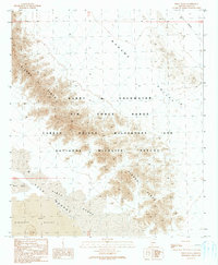
1990 Map of Pinta Playa
USGS Topo · Published 1990About this map
The Cabeza Prieta National Wildlife Refuge and Wilderness dominates this corner of Yuma County, Arizona, illustrating a landscape defined by sharp topographical contrasts and restricted access. The rugged peaks of the Sierra Pinta run northwest to southeast, separating the Mohawk Valley from the Tule Desert and the Pinta Sands. In the southwestern corner, the terrain transitions into the Pinacate Valley, where a specific section is noted for its Lava flows. This region is significantly shaped by its status as part of the Barry M Goldwater Air Force Range, a military training area established in the mid-20th century. The presence of the Pinta Playa near the desert floor indicates a dry lake bed, a crucial hydrological feature in this arid environment where water is scarce and drainage patterns are largely ephemeral.
Find a feature on this map
12 named features on this map. Tap any name to fly to it.
Don’t see what you’re looking for? This feature index may not catch every label — zoom into the map to look around manually.
Map Details
Editions of this 1990 Pinta Playa Map
This is the sole edition of this map. No revisions or reprints were ever made.
Other maps of this area

1953 · Ajo
USGS Topo · 1:250,000

1957 · Ajo
USGS Topo · 1:250,000

1958 · Ajo
USGS Topo · 1:250,000

1962 · Ajo
USGS Topo · 1:250,000

1963 · Ajo
USGS Topo · 1:250,000

1965 · O'Neill Hills
USGS Topo · 1:62,500

1965 · Granite Mountains
USGS Topo · 1:62,500

1965 · Isla Pinta
USGS Topo · 1:62,500

1965 · Sierra Arida
USGS Topo · 1:62,500

1967 · Ajo
USGS Topo · 1:250,000