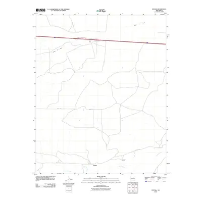
2010 Map of Pintada
USGS Topo · Published 2010About this map
Pintada sits at the southern edge of this Guadalupe County landscape, positioned where the terrain meets the winding course of the Pintada Arroyo. The area is defined by its ranching heritage and the sharp geographic relief of the Cañon de Baca in the north. This 2010 survey records the connectivity provided by County Rd 4 and the more remote County Rd 4EA as they traverse the high plains between small outposts. Genealogy and local history researchers will find the Old Pintada Cemetery clearly marked near the settlement of Pintada, serving as a primary point of interest for tracing the families who settled this high-desert region. Further north, the presence of York Ranch highlights the ongoing legacy of cattle ranching in a territory shaped by dry arroyos and canyons.
Find a feature on this map
9 named features on this map. Tap any name to fly to it.
Don’t see what you’re looking for? This feature index may not catch every label — zoom into the map to look around manually.
Map Details
Editions of this 2010 Pintada Map
This is the sole edition of this map. No revisions or reprints were ever made.
Other maps of this area

1890 · Bernal
USGS Topo · 1:125,000

1891 · Bernal
USGS Topo · 1:125,000

1892 · Corazon
USGS Topo · 1:125,000

1894 · Corazon
USGS Topo · 1:125,000

1894 · Bernal
USGS Topo · 1:125,000

1954 · Santa Fe
USGS Topo · 1:250,000

1954 · Fort Sumner
USGS Topo · 1:250,000

1958 · Fort Sumner
USGS Topo · 1:250,000

1958 · Santa Fe
USGS Topo · 1:250,000
1963 · Thompson Ranch
USGS Topo · 1:24,000