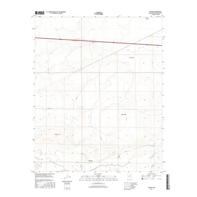
2017 Map of Pintada
USGS Topo · Published 2017About this map
Pintada is the central settlement in this high-desert landscape of Guadalupe County, appearing here in the early 21st century. The community is situated along the banks of the Pintada Arroyo, where the terrain transitions into a complex of drainage channels and plateaus. This area maintains deep ties to local heritage, evidenced by the presence of the Old Pintada Cem located just east of the main settlement. The map reveals a transition from traditional land use to modern infrastructure, where established routes like Pintada Rd and Sunset Rd connect the settlement to the wider region. Further north, the landscape is defined by the east-west corridor of Interstate 40, which cuts a straight path across the undulating topography. In the northeast corner, the Cañon de Baca provides a significant geographical landmark, marking the natural drainage patterns that have likely influenced settlement and ranching in this part of New Mexico for generations.
Find a feature on this map
15 named features on this map. Tap any name to fly to it.
Don’t see what you’re looking for? This feature index may not catch every label — zoom into the map to look around manually.
Map Details
Editions of this 2017 Pintada Map
This is the sole edition of this map. No revisions or reprints were ever made.
Other maps of this area

1890 · Bernal
USGS Topo · 1:125,000

1891 · Bernal
USGS Topo · 1:125,000

1892 · Corazon
USGS Topo · 1:125,000

1894 · Corazon
USGS Topo · 1:125,000

1894 · Bernal
USGS Topo · 1:125,000

1954 · Santa Fe
USGS Topo · 1:250,000

1954 · Fort Sumner
USGS Topo · 1:250,000

1958 · Fort Sumner
USGS Topo · 1:250,000

1958 · Santa Fe
USGS Topo · 1:250,000
1963 · Thompson Ranch
USGS Topo · 1:24,000