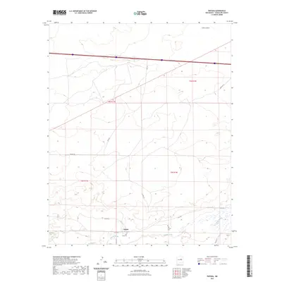
2023 Map of Pintada
USGS Topo · Published 2023About this map
Pintada anchors the southern portion of this Guadalupe County landscape, situated along the meandering course of the Pintada Arroyo. The area's cultural history is marked by the presence of the Old Pintada Cem and the Holy Family Cem, which reflect the community's ancestral roots and religious foundations. The terrain is defined by dry drainage systems and land divisions such as t8n r18e, with the northern reaches rising toward the Cañon de Baca. A network of rural routes, including Payne Rd and Milagro Rd, crisscross the territory, illustrating the sparse but deliberate connectivity of this high-plains region. The cartography reveals a transition from the narrow arroyo valley to the broader, open sections of the Pintada basin.
Find a feature on this map
18 named features on this map. Tap any name to fly to it.
Don’t see what you’re looking for? This feature index may not catch every label — zoom into the map to look around manually.
Map Details
Editions of this 2023 Pintada Map
This is the sole edition of this map. No revisions or reprints were ever made.
Other maps of this area

1890 · Bernal
USGS Topo · 1:125,000

1891 · Bernal
USGS Topo · 1:125,000

1892 · Corazon
USGS Topo · 1:125,000

1894 · Corazon
USGS Topo · 1:125,000

1894 · Bernal
USGS Topo · 1:125,000

1954 · Santa Fe
USGS Topo · 1:250,000

1954 · Fort Sumner
USGS Topo · 1:250,000

1958 · Fort Sumner
USGS Topo · 1:250,000

1958 · Santa Fe
USGS Topo · 1:250,000
1963 · Thompson Ranch
USGS Topo · 1:24,000