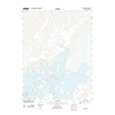
2011 Map of Pintail Bay
USGS Topo · Published 2011About this map
Pintail Bay and its surrounding wetlands dominate this desert landscape in Churchill County, where water management and seasonal landings define the local geography. The area is characterized by an intricate network of shallow basins and managed water bodies, including Swan Lake, Tule Lake, and the expansive Big Water. This hydrological system is supported by named infrastructure such as Swan Check and a series of access points that suggest a long history of riparian activity, notably South Swan Landing, Conradts Landing, and Peers Landing.
Find a feature on this map
23 named features on this map. Tap any name to fly to it.
Don’t see what you’re looking for? This feature index may not catch every label — zoom into the map to look around manually.
Map Details
Editions of this 2011 Pintail Bay Map
This is the sole edition of this map. No revisions or reprints were ever made.
Other maps of this area

1908 · Carson Sink
USGS Topo · 1:250,000

1910 · Carson Sink
USGS Topo · 1:250,000

1950 · Stillwater
USGS Topo · 1:62,500

1951 · Carson Sink
USGS Topo · 1:62,500

1957 · Reno
USGS Topo · 1:250,000

1959 · Reno
USGS Topo · 1:250,000

1960 · Reno
USGS Topo · 1:250,000
1969 · Lone Rock SW
USGS Topo · 1:24,000

1969 · Cox Canyon
USGS Topo · 1:24,000

1969 · Table Mtn
USGS Topo · 1:24,000