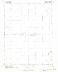
1969 Map of Lone Rock SW
USGS Topo · Published 1971About this map
Carson Sink dominates this minimalist desert landscape, revealing a stark environment of the late 1960s where the land is defined more by its geological depressions and military use than by human settlement. The central Alkali Flat (Depression) illustrates the remnants of prehistoric water bodies, now reduced to a dry expanse. To the northeast, the Navy Bombing Area marks the intrusion of modern defense needs into the basin, highlighting how this remote terrain was repurposed for training. Small pockets of Sand Dunes are the only significant topographic interruptions in an otherwise flat, unpopulated grid, reflecting the extreme isolation of Churchill County during this era of survey.
Find a feature on this map
4 named features on this map. Tap any name to fly to it.
Don’t see what you’re looking for? This feature index may not catch every label — zoom into the map to look around manually.
Map Details
Editions of this 1969 Lone Rock SW Map
2 editions found
Other maps of this area

1908 · Carson Sink
USGS Topo · 1:250,000

1910 · Carson Sink
USGS Topo · 1:250,000

1950 · Stillwater
USGS Topo · 1:62,500

1951 · Carson Sink
USGS Topo · 1:62,500

1957 · Reno
USGS Topo · 1:250,000

1959 · Reno
USGS Topo · 1:250,000

1960 · Reno
USGS Topo · 1:250,000

1969 · Cox Canyon
USGS Topo · 1:24,000

1969 · Pintail Bay
USGS Topo · 1:24,000
1969 · Lone Rock
USGS Topo · 1:24,000