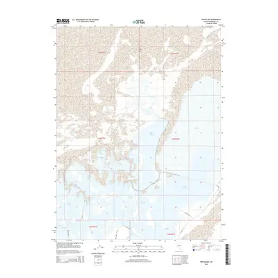
2014 Map of Pintail Bay
USGS Topo · Published 2014About this map
Pintail Bay and the vast Carson Sink define this Churchill County landscape, where complex water management systems intersect with natural wetlands. This 2014 survey documents a network of shallow lakes and marshlands, including Swan Lake, Willow Lake, and Tule Lake. The presence of the Lead Lake Canal and features like Swan Check illustrate the engineered hydrology required to manage water in this desert environment. Small roads and specialized access points, such as Navy Cabin Rd and the intriguing Conradts Lndg, provide the only infrastructure in an area dominated by the distinctive vegetation of North Nutgrass and West Nutgrass. This map captures a specific moment in the shifting boundaries of the sink before seasonal changes or larger climatic shifts alter the shoreline of Big Water.
Find a feature on this map
22 named features on this map. Tap any name to fly to it.
Don’t see what you’re looking for? This feature index may not catch every label — zoom into the map to look around manually.
Map Details
Editions of this 2014 Pintail Bay Map
This is the sole edition of this map. No revisions or reprints were ever made.
Other maps of this area

1908 · Carson Sink
USGS Topo · 1:250,000

1910 · Carson Sink
USGS Topo · 1:250,000

1950 · Stillwater
USGS Topo · 1:62,500

1951 · Carson Sink
USGS Topo · 1:62,500

1957 · Reno
USGS Topo · 1:250,000

1959 · Reno
USGS Topo · 1:250,000

1960 · Reno
USGS Topo · 1:250,000
1969 · Lone Rock SW
USGS Topo · 1:24,000

1969 · Cox Canyon
USGS Topo · 1:24,000

1969 · Table Mtn
USGS Topo · 1:24,000