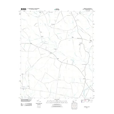
2011 Map of Pireway
USGS Topo · Published 2011About this map
The Waccamaw River corridor and the surrounding lowlands of the North Carolina-South Carolina border define this 2011 topographic study. Small communities like Pireway, Dulah, and Bug Hill are interconnected by a network of local roads that cross numerous watercourses, including Grissett Swamp and Big Cypress Swamp. The landscape is notably marked by family and community landmarks, such as Bethel Cemetery and Saint Stevens Cemetery, providing significant reference points for local history. Numerous named crossings, including Eddie Ford Bridges, Cane Break Bridges, and Ramsey Ford Bridges, highlight the historical necessity of navigating this complex wetland environment. The map details the transition from the upland settlements of Bethel and Pine Level toward the river flats, offering a precise view of the rural infrastructure in Columbus County during the early 21st century.
Find a feature on this map
88 named features on this map. Tap any name to fly to it.
Don’t see what you’re looking for? This feature index may not catch every label — zoom into the map to look around manually.
Map Details
Editions of this 2011 Pireway Map
This is the sole edition of this map. No revisions or reprints were ever made.
Other maps of this area

1937 · Nixonville
USGS Topo · 1:48,000

1942 · Nixonville
USGS Topo · 1:62,500

1943 · Pireway
USGS Topo · 1:31,680

1943 · Nakina
USGS Topo · 1:24,000

1943 · Calabash
USGS Topo · 1:31,680

1943 · Freeland
USGS Topo · 1:24,000

1944 · Longs
USGS Topo · 1:31,680

1949 · Georgetown
USGS Topo · 1:250,000

1953 · Longs
USGS Topo · 1:24,000
1953 · Calabash
USGS Topo · 1:24,000