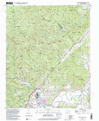
1997 Map of Pisgah Forest
USGS Topo · Published 2001About this map
The Davidson River valley and its confluence with the North Fork French Broad River define the settlement patterns of this Transylvania County landscape. While much of the terrain is preserved within the Pisgah National Forest and Pisgah Game Land, the lower elevations show the development of Brevard and smaller communities like Penrose and Blantyre. The infrastructure of the late 20th century is evident in the Blue Ridge Parkway winding across the northern ridges and the presence of a Quarry and Pumping Station near the riverbanks.
Find a feature on this map
142 named features on this map. Tap any name to fly to it.
Don’t see what you’re looking for? This feature index may not catch every label — zoom into the map to look around manually.
Map Details
Editions of this 1997 Pisgah Forest Map
This is the sole edition of this map. No revisions or reprints were ever made.
Other maps of this area

1905 · Pisgah
USGS Topo · 1:125,000

1906 · Pisgah
USGS Topo · 1:125,000

1935 · Cruso
USGS Topo · 1:24,000

1935 · Brevard
USGS Topo · 1:24,000

1935 · Standingstone Mtn.
USGS Topo · 1:24,000

1935 · Horse Shoe
USGS Topo · 1:24,000

1935 · Rosman
USGS Topo · 1:24,000

1935 · Shining Rock
USGS Topo · 1:24,000

1935 · Pisgah Forest
USGS Topo · 1:24,000

1936 · Skyland
USGS Topo · 1:24,000