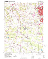
1995 Map of Pitman West
USGS Topo · Published 1999About this map
Raccoon Creek and its many tributaries, including Edwards Run and Clems Run, carve a distinct drainage pattern across this Gloucester County landscape. The settlement of Mullica Hill stands at a primary crossroads, featuring Mullica Hill Pond and several houses of worship such as Holy Name Ch and Trinity Ch. To the east, the urban expansion of Pitman and Glassboro is evident, characterized by a dense street grid, the Alcyon Lake recreational area at Alcyon Park, and local industrial footprints like the Sewage Disposal facility and various gravel pits.
Find a feature on this map
78 named features on this map. Tap any name to fly to it.
Don’t see what you’re looking for? This feature index may not catch every label — zoom into the map to look around manually.
Map Details
Editions of this 1995 Pitman West Map
This is the sole edition of this map. No revisions or reprints were ever made.
Other maps of this area

1890 · Salem
USGS Topo · 1:62,500

1890 · Glassboro
USGS Topo · 1:62,500

1891 · Philadelphia
USGS Topo · 1:62,500

1894 · Chester
USGS Topo · 1:62,500

1894 · Philadelphia
USGS Topo · 1:62,500

1896 · Philadelphia
USGS Topo · 1:62,500

1896 · Chester
USGS Topo · 1:62,500

1898 · Salem
USGS Topo · 1:62,500

1898 · Glassboro
USGS Topo · 1:62,500

1898 · Chester
USGS Topo · 1:62,500