
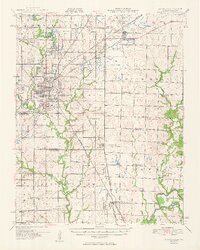
1950 Map of Pittsburg
USGS Topo · Published 1950About this map
Extensive Strip Mine operations dominate the landscape between Pittsburg and Mindenmines at the mid-century, following the border between Kansas and Missouri. This coal-driven economy is etched into the terrain through countless excavations and an intricate rail network including the Kansas City Southern, Missouri Pacific, and St Louis San Francisco lines. While industrial activity is concentrated to the north and west, the southern and eastern portions of the sheet transition into agricultural lands drained by the Spring River and its various forks. Numerous rural institutions serve these scattered communities, from the Mindenmines Cem and Georgia City Cem to a dense network of country schools like Neutral Sch, Owsley Sch, and Silver Creek Sch. The map also captures the early footprint of the Atkinson Municipal Airport and the layout of regional hubs like Frontenac, revealing the intersection of heavy industry and rural settlement.
Find a feature on this map
79 named features on this map. Tap any name to fly to it.
Don’t see what you’re looking for? This feature index may not catch every label — zoom into the map to look around manually.
Map Details
Editions of this 1950 Pittsburg Map
2 editions found
Other maps of this area

1884 · Fort Scott
USGS Topo · 1:125,000

1886 · Nevada
USGS Topo · 1:125,000

1886 · Joplin
USGS Topo · 1:125,000

1886 · Fort Scott
USGS Topo · 1:125,000

1886 · Carthage
USGS Topo · 1:125,000

1893 · Fort Scott
USGS Topo · 1:125,000

1894 · Nevada
USGS Topo · 1:125,000

1894 · Joplin
USGS Topo · 1:125,000

1894 · Carthage
USGS Topo · 1:125,000

1918 · Columbus
USGS Topo · 1:62,500