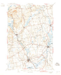
1932 Map of Pittsfield
USGS Topo · Published 1942About this map
Pittsfield and its neighboring mill towns are defined by the convergence of industrial rail and winding watercourses during the early 1930s. The Maine Central Railroad serves as a vital artery, connecting the settlement at Hartland on the Sebasticook River to the agricultural and timber hubs at Corinna and Newport. A dense network of local schoolhouses, including Merrill Sch, Hopkins Sch, and Mills Sch, illustrates the distributed rural population of the era.
Find a feature on this map
152 named features on this map. Tap any name to fly to it.
Don’t see what you’re looking for? This feature index may not catch every label — zoom into the map to look around manually.
Map Details
Editions of this 1932 Pittsfield Map
3 editions found
Other maps of this area

1892 · Waterville
USGS Topo · 1:62,500

1913 · Skowhegan
USGS Topo · 1:62,500

1926 · Burnham
USGS Topo · 1:62,500

1930 · Pittsfield
USGS Topo · 1:48,000

1931 · Stetson
USGS Topo · 1:48,000

1932 · Brooks
USGS Topo · 1:62,500

1932 · Dover-Foxcroft
USGS Topo · 1:48,000

1932 · Pittsfield
USGS Topo · 1:62,500

1933 · Pittsfield
USGS Topo · 1:62,500

1933 · Guilford
USGS Topo · 1:62,500