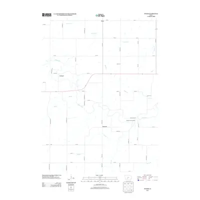
2013 Map of Pitzer
USGS Topo · Published 2013About this map
The Middle River winds through the rural landscape of Madison County, Iowa, anchoring a network of agricultural settlements and historic stream crossings. This 2013 survey documents the enduring presence of the Roseman Covered Bridge, a significant local landmark located along Roseman Bridge Rd south of the river. The surrounding terrain is defined by its small crossroads communities, including Pitzer, Webster, Harrison, and Maple Grove, which served as local hubs for the township's farming families.
Find a feature on this map
48 named features on this map. Tap any name to fly to it.
Don’t see what you’re looking for? This feature index may not catch every label — zoom into the map to look around manually.
Map Details
Editions of this 2013 Pitzer Map
This is the sole edition of this map. No revisions or reprints were ever made.
Other maps of this area

1951 · Afton
USGS Topo · 1:62,500

1952 · Winterset
USGS Topo · 1:62,500

1954 · Greenfield
USGS Topo · 1:62,500

1954 · Omaha
USGS Topo · 1:250,000

1957 · Omaha
USGS Topo · 1:250,000

1958 · Omaha
USGS Topo · 1:250,000

1981 · Zion
USGS Topo · 1:24,000
1983 · Earlham West
USGS Topo · 1:24,000
1983 · Stuart South
USGS Topo · 1:24,000
1983 · Pitzer
USGS Topo · 1:24,000