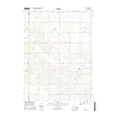
2015 Map of Pitzer
USGS Topo · Published 2015About this map
The Roseman Covered Bridge spans the Middle River in this rural section of Madison County, a region defined by its winding waterways and deeply rooted agricultural heritage. The landscape is carved by numerous tributaries including Welty Cr, Howerdon Cr, and Baugh Br, which flow through a network of section-line roads and family-named landmarks. Small clusters of settlement at Pitzer and Webster serve as local anchors, while the presence of several established burial grounds, such as Wintermantle Cem, Wight Cem, and Pleasant View Cem, provides significant points of interest for genealogists tracking the area's early families. The transition from the Adair County line on the west into the heart of Madison County is marked by a shift in the road grid, featuring thoroughfares like Adair-Madison Ave and Roseman Bridge Rd.
Find a feature on this map
53 named features on this map. Tap any name to fly to it.
Don’t see what you’re looking for? This feature index may not catch every label — zoom into the map to look around manually.
Map Details
Editions of this 2015 Pitzer Map
This is the sole edition of this map. No revisions or reprints were ever made.
Other maps of this area

1951 · Afton
USGS Topo · 1:62,500

1952 · Winterset
USGS Topo · 1:62,500

1954 · Greenfield
USGS Topo · 1:62,500

1954 · Omaha
USGS Topo · 1:250,000

1957 · Omaha
USGS Topo · 1:250,000

1958 · Omaha
USGS Topo · 1:250,000

1981 · Zion
USGS Topo · 1:24,000
1983 · Earlham West
USGS Topo · 1:24,000
1983 · Stuart South
USGS Topo · 1:24,000
1983 · Pitzer
USGS Topo · 1:24,000