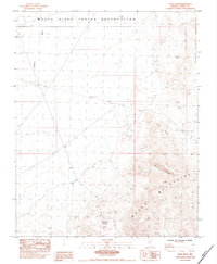
1983 Map of Piute Point
USGS Topo · Published 1984About this map
The Moapa River Indian Reservation occupies the northernmost portion of this Clark County landscape, where the flat, open terrain of California Wash meets the rising elevations of the North Muddy Mountains. Surveyed in the early 1980s, the map reveals a stark arid environment shaped by significant geological formations. The Muddy Mountains dominate the southern half of the quadrangle, characterized by the unique Buffington Pockets and the sloping expanse of Monocline Valley. While largely undeveloped, human efforts to manage the desert's occasional water are evident through the presence of Catch Basins and a Conc Dam, located near the high vantage of Piute Point. This provisional survey preserves the topographical details of a transition zone between tribal lands and the high ridges of southern Nevada.
Find a feature on this map
12 named features on this map. Tap any name to fly to it.
Don’t see what you’re looking for? This feature index may not catch every label — zoom into the map to look around manually.
Map Details
Editions of this 1983 Piute Point Map
This is the sole edition of this map. No revisions or reprints were ever made.
Other maps of this area

1886 · Saint Thomas
USGS Topo · 1:250,000

1893 · Saint Thomas
USGS Topo · 1:250,000

1926 · Boulder Canyon
USGS Topo · 1:96,000

1952 · Dry Lake
USGS Topo · 1:62,500

1953 · Muddy Peak
USGS Topo · 1:62,500

1954 · Las Vegas
USGS Topo · 1:250,000

1957 · Las Vegas
USGS Topo · 1:250,000

1958 · Arrow Canyon
USGS Topo · 1:62,500

1958 · Moapa
USGS Topo · 1:62,500

1959 · Las Vegas
USGS Topo · 1:250,000