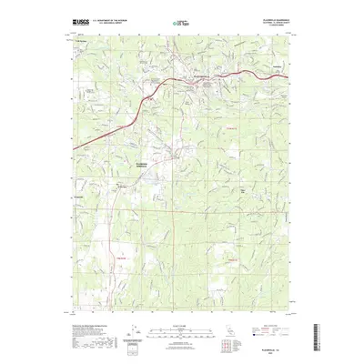
2022 Map of Placerville
USGS Topo · Published 2022About this map
Placerville and the surrounding Sierra Nevada foothills are captured in this modern survey, highlighting a landscape defined by its deep gold-rush heritage and complex ravine topography. The map illustrates a dense concentration of historical burial sites, including the Placerville Union Cem, Pioneer Cem, and the Jewish Cem, reflecting the diverse pioneer populations that settled here. Beyond the city center, smaller communities like Diamond Springs, Smithflat, and Kingsville dot the terrain, linked by thoroughfares such as Mother Lode Dr and Missouri Flat Rd. Water management remains a critical feature of the landscape, seen in the El Dorado Irrigation Main Canal and numerous creeks like Hangtown Cr and Weber Cr. The transition from urban density to the steeper terrain of Logtown Ridge and Coon Hollow demonstrates the ongoing balance between historical settlement patterns and the natural constraints of the California foothills.
Find a feature on this map
118 named features on this map. Tap any name to fly to it.
Don’t see what you’re looking for? This feature index may not catch every label — zoom into the map to look around manually.
Map Details
Editions of this 2022 Placerville Map
This is the sole edition of this map. No revisions or reprints were ever made.
Other maps of this area

1891 · Placerville
USGS Topo · 1:125,000

1892 · Placerville
USGS Topo · 1:125,000

1893 · Placerville
USGS Topo · 1:125,000

1947 · Sacramento
USGS Topo · 1:250,000

1948 · Sacramento
USGS Topo · 1:250,000

1949 · Georgetown
USGS Topo · 1:62,500

1949 · Placerville
USGS Topo · 1:62,500

1949 · Placerville
USGS Topo · 1:24,000
1949 · Coloma
USGS Topo · 1:24,000
1949 · Latrobe
USGS Topo · 1:24,000