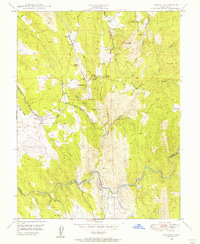
1949 Map of Latrobe
USGS Topo · Published 1956About this map
Latrobe serves as a central hub for this portion of the Sierra Nevada foothills, where the Southern Pacific railroad cuts through the landscape near Ben Bolt Ridge. The map documents a transition from active to legacy mining, noting several significant sites including the Vandalia Mine (Inactive), Big Canyon Mine, and Copper Hill Mine. These workings, along with the Chinese Cem near Fanny Creek, point to the intensive extraction history of El Dorado County.
Find a feature on this map
35 named features on this map. Tap any name to fly to it.
Don’t see what you’re looking for? This feature index may not catch every label — zoom into the map to look around manually.
Map Details
Editions of this 1949 Latrobe Map
3 editions found

Other maps of this area

1889 · Jackson
USGS Topo · 1:125,000

1891 · Sacramento
USGS Topo · 1:125,000

1891 · Placerville
USGS Topo · 1:125,000

1892 · Jackson
USGS Topo · 1:125,000

1892 · Sacramento
USGS Topo · 1:125,000

1892 · Placerville
USGS Topo · 1:125,000

1893 · Placerville
USGS Topo · 1:125,000

1893 · Sacramento
USGS Topo · 1:125,000

1894 · Lodi
USGS Topo · 1:125,000

1897 · Jackson
USGS Topo · 1:125,000