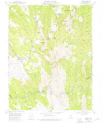
1949 Map of Latrobe
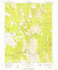
USGS Topo · Published 1977About this map
Latrobe serves as the focal point for this survey of the foothills where El Dorado and Amador counties meet. The Southern Pacific railroad cuts a diagonal path through the landscape, connecting small rural outposts like Bullard, Dugan, and Brela. The terrain is deeply marked by its mining history, evidenced by numerous extractive sites including the Vandalia Mine, Big Canyon Mine, and Sugarloaf Mine. Along the eastern edge, the presence of a Chinese Cem near Fanny Creek speaks to the diverse labor force that once worked these hills.
Find a feature on this map
40 named features on this map. Tap any name to fly to it.
Don’t see what you’re looking for? This feature index may not catch every label — zoom into the map to look around manually.
Map Details
Editions of this 1949 Latrobe Map
3 editions found

Other maps of this area

1889 · Jackson
USGS Topo · 1:125,000

1891 · Sacramento
USGS Topo · 1:125,000

1891 · Placerville
USGS Topo · 1:125,000

1892 · Jackson
USGS Topo · 1:125,000

1892 · Sacramento
USGS Topo · 1:125,000

1892 · Placerville
USGS Topo · 1:125,000

1893 · Placerville
USGS Topo · 1:125,000

1893 · Sacramento
USGS Topo · 1:125,000

1894 · Lodi
USGS Topo · 1:125,000

1897 · Jackson
USGS Topo · 1:125,000