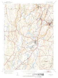
1953 Map of Plainfield
USGS Topo · Published 1955About this map
The Quinebaug River dictates the industrial and social geometry of this portion of Windham County, where the New York New Haven and Hartford railroad parallels the water to serve textile and manufacturing hubs. Dense village clusters like Wauregan and Moosup are shown at a high level of detail, reflecting the era's transition from early industrial centers to post-war residential expansion. In Plainfield, the concentration of structures around Evans Pond and the presence of a Drive-in Theater along Tarbox Road illustrate the shift toward automobile-centered recreation.
Find a feature on this map
43 named features on this map. Tap any name to fly to it.
Don’t see what you’re looking for? This feature index may not catch every label — zoom into the map to look around manually.
Map Details
Editions of this 1953 Plainfield Map
6 editions found
Other maps of this area

1889 · Putnam
USGS Topo · 1:62,500

1889 · Moosup
USGS Topo · 1:62,500

1892 · Woodstock
USGS Topo · 1:62,500

1892 · Norwich
USGS Topo · 1:62,500

1893 · Putnam
USGS Topo · 1:62,500

1893 · Moosup
USGS Topo · 1:62,500

1919 · Putnam
USGS Topo · 1:62,500

1920 · Moosup
USGS Topo · 1:62,500

1921 · Woodstock
USGS Topo · 1:62,500
1943 · Voluntown
USGS Topo · 1:31,680