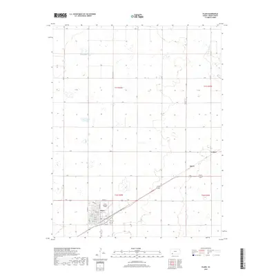
2018 Map of Plains
USGS Topo · Published 2018About this map
Plains serves as the primary hub of activity in this section of Meade County, characterized by a structured grid of residential streets such as Ohio St and Indiana. The settlement is supported by infrastructure like the Plains Municipal Airport and the local Plains Cem. Outside the main town, the landscape transitions into a vast agricultural and prairie expanse defined by a rigorous letter-designated road system, including H Rd and P Rd. Scattered settlements like Hobart and Collano appear as smaller points of interest along the rail and road corridors. Natural hydrography is sparse but distinctive, featuring Wildhorse Lake in the north and the seasonal drainage of Spring Cr to the northeast. The presence of large-scale township and range divisions, such as t31s r30w, illustrates the enduring impact of the Public Land Survey System on the development of the High Plains.
Find a feature on this map
30 named features on this map. Tap any name to fly to it.
Don’t see what you’re looking for? This feature index may not catch every label — zoom into the map to look around manually.
Map Details
Editions of this 2018 Plains Map
This is the sole edition of this map. No revisions or reprints were ever made.
Other maps of this area

1892 · Meade
USGS Topo · 1:125,000

1955 · Dodge City
USGS Topo · 1:250,000

1958 · Dodge City
USGS Topo · 1:250,000

1959 · Dodge City
USGS Topo · 1:250,000

1963 · Plains
USGS Topo · 1:24,000

1963 · Kismet NE
USGS Topo · 1:24,000

1963 · Lake Larrabee
USGS Topo · 1:24,000

1963 · Missler
USGS Topo · 1:24,000

1967 · Plains NE
USGS Topo · 1:24,000

1968 · Plains SW
USGS Topo · 1:24,000