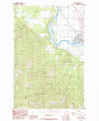
1985 Map of Plains
USGS Topo · Published 1985About this map
Plains sits at a strategic bend of the Clark Fork, where the river valley widens between the heavily timbered slopes of the Lolo National Forest. This 1985 survey captures the town's layout during a period when the timber industry and river geography dictated local development. The map details the drainage patterns of several vital waterways, including Lynch Creek and Swamp Creek, which feed into the main river channel from the north and west. To the south, the topography rises sharply toward Combest Peak, a prominent landmark overlooking the confluence of Miller Creek and Combest Creek. The interface between the valley floor and the steep terrain of Graham Gulch highlights the physical constraints that have shaped the growth of this Sanders County community. The inclusion of the local Airport and the surveyed boundary between Sanders and Mineral counties further grounds the map in its mid-1980s administrative context.
Find a feature on this map
15 named features on this map. Tap any name to fly to it.
Don’t see what you’re looking for? This feature index may not catch every label — zoom into the map to look around manually.
Map Details
Editions of this 1985 Plains Map
This is the sole edition of this map. No revisions or reprints were ever made.
Other maps of this area

1918 · St Regis
USGS Topo · 1:125,000

1919 · St. Regis
USGS Topo · 1:125,000

1937 · Thompson Falls
USGS Topo · 1:125,000

1956 · St Regis
USGS Topo · 1:62,500

1956 · Wallace
USGS Topo · 1:250,000

1959 · Plains
USGS Topo · 1:62,500

1960 · Wallace
USGS Topo · 1:250,000
1964 · Big Hole Peak
USGS Topo · 1:24,000

1964 · Baldy Lake
USGS Topo · 1:24,000

1964 · Weeksville
USGS Topo · 1:24,000