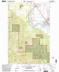
1999 Map of Plains
USGS Topo · Published 2003About this map
Plains sits along a broad bend of the Clark Fork river, serving as a hub between the Coeur d'Alene Mountains and the expansive Lolo National Forest. The town’s social and civic layout is clearly defined, featuring a Fairground, an Airport, and a local Cem on its eastern edge. Agricultural and forest management interests are evident through the Plains Seed Orchard to the north and the Plains Superior Ranger District infrastructure, including a Ranger Sta. Beyond the river valley, the terrain rises sharply toward Combest Peak, where the map identifies Mines and various drainages like Combest Creek and Miller Creek. This 1990s revision by the Forest Service highlights the intersection of municipal life and federal land management in western Montana, documenting the specific boundary between Sanders Co and Mineral Co in the southern reaches of the quadrangle.
Find a feature on this map
26 named features on this map. Tap any name to fly to it.
Don’t see what you’re looking for? This feature index may not catch every label — zoom into the map to look around manually.
Map Details
Editions of this 1999 Plains Map
This is the sole edition of this map. No revisions or reprints were ever made.
Other maps of this area

1918 · St Regis
USGS Topo · 1:125,000

1919 · St. Regis
USGS Topo · 1:125,000

1937 · Thompson Falls
USGS Topo · 1:125,000

1956 · St Regis
USGS Topo · 1:62,500

1956 · Wallace
USGS Topo · 1:250,000

1959 · Plains
USGS Topo · 1:62,500

1960 · Wallace
USGS Topo · 1:250,000
1964 · Big Hole Peak
USGS Topo · 1:24,000

1964 · Baldy Lake
USGS Topo · 1:24,000

1964 · Weeksville
USGS Topo · 1:24,000