
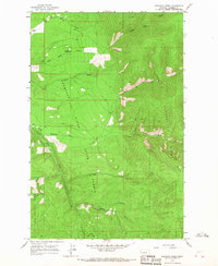
1964 Map of Baldy Lake
USGS Topo · Published 1967About this map
Baldy Mountain dominates the high country in this mid-1960s study, where a Lookout Tower and Baldy Lake sit amidst the rugged terrain of the Lolo National Forest. The landscape is defined by the Flathead Indian Reservation Boundary which runs north-south across the eastern section of the map. To the south, recreation and geography converge at Rainbow Lake, which features a designated Campground and Picnic Area near Rainbow Lake Pass. This map illustrates a transition from the lower elevations near Blanchards Corner and the Thompson River to the high mountain interior. Researchers can trace numerous watercourses that drain the slopes, including Cedar Creek, Clark Creek, and McGinnis Creek. A solitary Pack Trail is marked in the northwest, suggesting the limited accessibility of the high ridges before more modern road networks were established.
Find a feature on this map
23 named features on this map. Tap any name to fly to it.
Don’t see what you’re looking for? This feature index may not catch every label — zoom into the map to look around manually.
Map Details
Editions of this 1964 Baldy Lake Map
This is the sole edition of this map. No revisions or reprints were ever made.
Other maps of this area

1956 · Wallace
USGS Topo · 1:250,000

1959 · Perma
USGS Topo · 1:62,500

1959 · Plains
USGS Topo · 1:62,500

1960 · Wallace
USGS Topo · 1:250,000

1964 · Coney Peak
USGS Topo · 1:24,000

1964 · Weeksville
USGS Topo · 1:24,000

1964 · Lonepine
USGS Topo · 1:24,000

1964 · Hot Springs
USGS Topo · 1:24,000
1964 · Loneman Creek
USGS Topo · 1:24,000
1980 · Polson
USGS Topo · 1:100,000