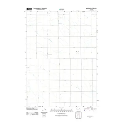
2011 Map of Plainview NE
USGS Topo · Published 2011About this map
Spring Creek and Breslau Creek carve subtle paths through this agricultural section of Pierce County, defining the drainage patterns of the rural landscape. This 2011 survey documents a precise grid of sectional roads, including north-south corridors like 533 Ave and 534 Ave, which facilitate the region's farming economy. The map illustrates a highly organized township-and-range system, where arterial routes such as 870 Rd and 866 Rd intersect at regular intervals. This topography is characteristic of the Nebraska plains, where the utility of the land is mapped through its drainage and transportation network rather than concentrated urban centers. For researchers, it provides a clear record of property access and land divisions during the early 21st century.
Find a feature on this map
18 named features on this map. Tap any name to fly to it.
Don’t see what you’re looking for? This feature index may not catch every label — zoom into the map to look around manually.
Map Details
Editions of this 2011 Plainview NE Map
This is the sole edition of this map. No revisions or reprints were ever made.
Other maps of this area

1955 · Sioux City
USGS Topo · 1:250,000

1958 · Sioux City
USGS Topo · 1:250,000

1959 · Sioux City
USGS Topo · 1:250,000

1963 · Plainview
USGS Topo · 1:24,000

1963 · Brunswick
USGS Topo · 1:24,000

1963 · Foster
USGS Topo · 1:24,000

1974 · Midland
USGS Topo · 1:24,000
1974 · Center West
USGS Topo · 1:24,000
1974 · Creighton
USGS Topo · 1:24,000

1974 · Bloomfield
USGS Topo · 1:24,000