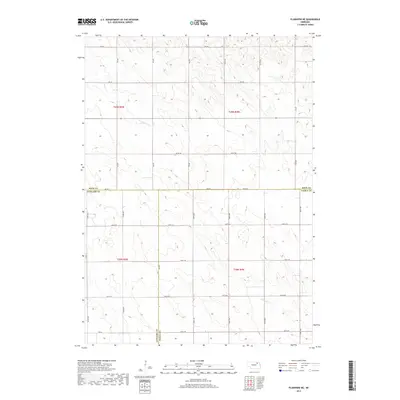
2017 Map of Plainview NE
USGS Topo · Published 2017About this map
The triple-county boundary of Knox Co, Antelope Co, and Pierce Co meets in this rural section of northeast Nebraska, defining a landscape carved by subtle drainage patterns. The northern half of the region is drained by Spring Creek, while the southern reaches fall toward Breslau Creek, reflecting the gentle divide between the townships of t29n r5w and t28n r4w. This 2017 topographic record documents the established section-line road network that governs the agricultural layout of the plains, with thoroughfares such as 870th Rd and 533rd Ave providing the primary transit structure for local farmsteads. The regularity of the survey grid, highlighted by the demarcation of t29n r4w and t28n r5w, illustrates the enduring influence of the Public Land Survey System on Nebraska's modern geography.
Find a feature on this map
32 named features on this map. Tap any name to fly to it.
Don’t see what you’re looking for? This feature index may not catch every label — zoom into the map to look around manually.
Map Details
Editions of this 2017 Plainview NE Map
This is the sole edition of this map. No revisions or reprints were ever made.
Other maps of this area

1955 · Sioux City
USGS Topo · 1:250,000

1958 · Sioux City
USGS Topo · 1:250,000

1959 · Sioux City
USGS Topo · 1:250,000

1963 · Plainview
USGS Topo · 1:24,000

1963 · Brunswick
USGS Topo · 1:24,000

1963 · Foster
USGS Topo · 1:24,000

1974 · Midland
USGS Topo · 1:24,000
1974 · Center West
USGS Topo · 1:24,000
1974 · Creighton
USGS Topo · 1:24,000

1974 · Bloomfield
USGS Topo · 1:24,000