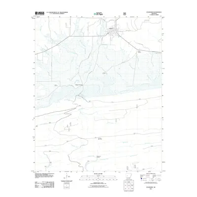
2011 Map of Plainview
USGS Topo · Published 2011About this map
Plainview sits at the northern edge of this Arkansas landscape, where a network of local roads like Tippy Ln and Linzy Ln connect the town to the surrounding countryside. The terrain is defined by the significant corridor of the Fourche LaFave River, which is fed by numerous drainages including Porter Creek and Prairie Creek. To the south, the topography rises sharply at Fourche Mountain, creating a distinct barrier between the river valley and Buchanan Hollow. Genealogists will find several burial sites preserved across the map, such as Sunlight Cemetery and Barnett Chapel Cemetery near the eastern reaches of the river, as well as Hogan Cemetery near the historic Wards Crossing. The complex system of creeks, including Moore Creek and Hogan Creek, illustrates the drainage patterns typical of this region's varied elevation.
Find a feature on this map
44 named features on this map. Tap any name to fly to it.
Don’t see what you’re looking for? This feature index may not catch every label — zoom into the map to look around manually.
Map Details
Editions of this 2011 Plainview Map
This is the sole edition of this map. No revisions or reprints were ever made.
Other maps of this area

1888 · Dardanelle #4
USGS Topo · 1:62,500

1888 · Dardanelle #3
USGS Topo · 1:62,500

1890 · Hot Springs
USGS Topo · 1:125,000

1890 · Dardanelle
USGS Topo · 1:125,000

1894 · Hot Springs
USGS Topo · 1:125,000

1955 · Little Rock
USGS Topo · 1:250,000

1956 · Little Rock
USGS Topo · 1:250,000

1956 · Russellville
USGS Topo · 1:250,000

1960 · Little Rock
USGS Topo · 1:250,000

1964 · Russellville
USGS Topo · 1:250,000