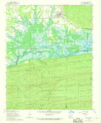
1968 Map of Plainview
USGS Topo · Published 1970About this map
Plainview serves as the primary settlement on this landscape, situated just north of the managed waters of Nimrod Lake. The town is characterized by its organized grid and local infrastructure, including a prominent Water Tank and the nearby Barnett Chapel and its associated Barnett Chapel Cem. The topography transitions sharply from the lowlands around the Fourche La Fave River to the high, wooded ridges of the Ouachita National Forest in the south, where Long Mountain and Fourche Mountain dominate the horizon.
Find a feature on this map
36 named features on this map. Tap any name to fly to it.
Don’t see what you’re looking for? This feature index may not catch every label — zoom into the map to look around manually.
Map Details
Editions of this 1968 Plainview Map
This is the sole edition of this map. No revisions or reprints were ever made.
Other maps of this area

1888 · Dardanelle #4
USGS Topo · 1:62,500

1888 · Dardanelle #3
USGS Topo · 1:62,500

1890 · Hot Springs
USGS Topo · 1:125,000

1890 · Dardanelle
USGS Topo · 1:125,000

1894 · Hot Springs
USGS Topo · 1:125,000

1955 · Little Rock
USGS Topo · 1:250,000

1956 · Little Rock
USGS Topo · 1:250,000

1956 · Russellville
USGS Topo · 1:250,000

1960 · Little Rock
USGS Topo · 1:250,000

1964 · Russellville
USGS Topo · 1:250,000