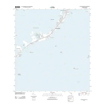
2012 Map of Plantation Key
USGS Topo · Published 2012About this map
Plantation Key dominates this coastal survey, showcasing a string of Upper Keys communities connected by the Overseas Highway during the early 2010s. The geography transitions from the residential developments of Plantation Key Colony and Plantation down to the established waterfront of Islamorada on Upper Matecumbe Key. This maritime landscape is defined by its specialized infrastructure, including the Plantation Key Seaplane Base and the Holiday Isle Seaplane Base, highlighting the importance of aerial and amphibious access to these islands.
Find a feature on this map
66 named features on this map. Tap any name to fly to it.
Don’t see what you’re looking for? This feature index may not catch every label — zoom into the map to look around manually.
Map Details
Editions of this 2012 Plantation Key Map
This is the sole edition of this map. No revisions or reprints were ever made.
Other maps of this area

1947 · Rock Harbor
USGS Topo · 1:24,000

1949 · Rock Harbor
USGS Topo · 1:24,000

1956 · Miami
USGS Topo · 1:250,000

1958 · Miami
USGS Topo · 1:250,000

1971 · Upper Matecumbe Key
USGS Topo · 1:24,000

1971 · Tavernier
USGS Topo · 1:24,000

1971 · Plantation Key
USGS Topo · 1:24,000
1971 · Lower Matecumbe Key
USGS Topo · 1:24,000

1972 · Calusa Keys
USGS Topo · 1:24,000
1982 · Homestead
USGS Topo · 1:100,000
Featured Places
- Islamorada, FL
- Plantation Key Colony, Islamorada
- Plantation Key, FL
- Plantation, Islamorada
- Monroe County, FL