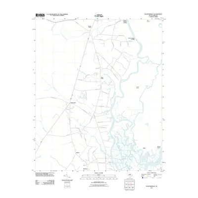
2011 Map of Plantersville
USGS Topo · Published 2011About this map
Great Pee-Dee-River and its intricate network of tributaries dominate this coastal South Carolina landscape, defining the boundaries of local life and industry. The winding water of Thoroughfare Creek and Guendalose Creek weave through low-lying marshlands and island formations like Sandy Island and Bull Island. This 2011 survey reveals a settlement pattern largely dictated by the river system, with landing points such as Upper Topsaw Landing and Lower Topsaw Landing serving as critical access points. Inland, small communities like Plantersville and Saint Pauls are linked by a network of rural roads such as Plantersville Rd and Exodus Dr. The transition from the Black Swamp in the west to the confluence of the Waccamaw River and Prince Creek in the southeast highlights the complex hydrography of the Georgetown County coastline.
Find a feature on this map
62 named features on this map. Tap any name to fly to it.
Don’t see what you’re looking for? This feature index may not catch every label — zoom into the map to look around manually.
Map Details
Editions of this 2011 Plantersville Map
This is the sole edition of this map. No revisions or reprints were ever made.
Other maps of this area

1942 · Magnolia Beach
USGS Topo · 1:24,000

1942 · Waverly Mills
USGS Topo · 1:24,000

1943 · Yauhannah
USGS Topo · 1:24,000

1943 · Bucksville
USGS Topo · 1:24,000

1943 · Carvers Bay
USGS Topo · 1:24,000

1943 · Brookgreen
USGS Topo · 1:24,000

1943 · Plantersville
USGS Topo · 1:24,000

1943 · Georgetown North
USGS Topo · 1:24,000

1943 · Outland
USGS Topo · 1:24,000

1944 · Outland
USGS Topo · 1:31,680