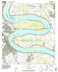
1998 Map of Plaquemine
USGS Topo · Published 2003About this map
The Mississippi River carves a deep, serpentine path through this Iberville Parish landscape, creating massive peninsulas like Manchac Point and Plaquemine Point. The city of Plaquemine serves as the focal point, situated at the junction where Bayou Plaquemine meets the river, featuring the historic Plaquemine Lock. The region's plantation history is visibly preserved through named tracts such as St Louis Plantation, Cottage Plantation, and Evergreen Plantation, which sit alongside established riverbank settlements like Sunshine and Seymourville.
Find a feature on this map
66 named features on this map. Tap any name to fly to it.
Don’t see what you’re looking for? This feature index may not catch every label — zoom into the map to look around manually.
Map Details
Editions of this 1998 Plaquemine Map
This is the sole edition of this map. No revisions or reprints were ever made.
Other maps of this area

1908 · Baton Rouge
USGS Topo · 1:62,500

1935 · Chicot Lake
USGS Topo · 1:62,500

1936 · White Castle
USGS Topo · 1:62,500

1939 · Baton Rouge
USGS Topo · 1:62,500

1940 · Grosse Tete
USGS Topo · 1:62,500

1953 · Baton Rouge West
USGS Topo · 1:24,000

1953 · Crescent
USGS Topo · 1:24,000

1953 · Plaquemine
USGS Topo · 1:24,000

1953 · Lobdell
USGS Topo · 1:24,000

1953 · Addis
USGS Topo · 1:24,000