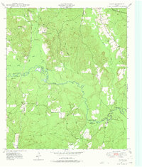
1949 Map of Platt
USGS Topo · Published 1975About this map
The Angelina River meanders through the heart of the East Texas timberlands, forming the winding border between Nacogdoches and Angelina counties. Surveyed in the late 1940s, this landscape is defined by its intricate drainage network of sloughs and creeks, including Boggy Slough and Dorr Creek. Small communities and family landmarks are scattered throughout the piney woods, such as the settlement of Platt and the nearby Poe.
Find a feature on this map
26 named features on this map. Tap any name to fly to it.
Don’t see what you’re looking for? This feature index may not catch every label — zoom into the map to look around manually.
Map Details
Editions of this 1949 Platt Map
Other maps of this area

1949 · Lufkin
USGS Topo · 1:62,500

1949 · Platt
USGS Topo · 1:24,000

1949 · Lufkin
USGS Topo · 1:24,000

1949 · Huntington
USGS Topo · 1:24,000

1950 · Platt
USGS Topo · 1:24,000

1950 · Lufkin
USGS Topo · 1:24,000

1950 · Redland
USGS Topo · 1:24,000

1950 · Huntington
USGS Topo · 1:24,000

1952 · Nacogdoches
USGS Topo · 1:62,500

1953 · Palestine
USGS Topo · 1:250,000