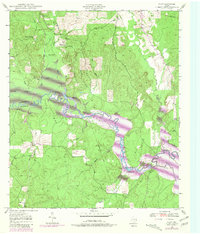
1949 Map of Platt
USGS Topo · Published 1981About this map
The Angelina River meanders across this landscape on the border of Nacogdoches and Angelina counties, showing the transition of the river bottom before the full impact of the Sam Rayburn Reservoir. Revisions from 1980, shown in purple, indicate significant areas designated to be submerged at elevation 164, including portions of the Boggy Slough and land near the Site of Marion. The settlement of Platt serves as a local anchor near the convergence of Moccasin Creek and Dorty Creek.
Find a feature on this map
28 named features on this map. Tap any name to fly to it.
Don’t see what you’re looking for? This feature index may not catch every label — zoom into the map to look around manually.
Map Details
Editions of this 1949 Platt Map
Other maps of this area

1949 · Lufkin
USGS Topo · 1:62,500

1949 · Platt
USGS Topo · 1:24,000

1949 · Lufkin
USGS Topo · 1:24,000

1949 · Huntington
USGS Topo · 1:24,000

1950 · Platt
USGS Topo · 1:24,000

1950 · Lufkin
USGS Topo · 1:24,000

1950 · Redland
USGS Topo · 1:24,000

1950 · Huntington
USGS Topo · 1:24,000

1952 · Nacogdoches
USGS Topo · 1:62,500

1953 · Palestine
USGS Topo · 1:250,000