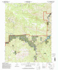
1994 Map of Platte Canyon
USGS Topo · Published 1998About this map
The North Fork South Platte River carves through the landscape, meeting the main river channel at the settlement of South Platte. This 1994 revision, based on photographs dating back to 1964, shows a mountain community defined by a mix of forestry, ranching, and outdoor recreation. The Pike National Forest covers much of the southern terrain, where hikers can trace the Colorado Trail as it winds past landmarks like Raleigh Peak and the Chair Rocks.
Find a feature on this map
42 named features on this map. Tap any name to fly to it.
Don’t see what you’re looking for? This feature index may not catch every label — zoom into the map to look around manually.
Map Details
Editions of this 1994 Platte Canyon Map
This is the sole edition of this map. No revisions or reprints were ever made.
Other maps of this area

1893 · Platte Canyon
USGS Topo · 1:125,000

1899 · West Denver
USGS Topo · 1:125,000

1942 · Littleton
USGS Topo · 1:31,680

1945 · Indian Hills
USGS Topo · 1:31,680

1945 · Platte Canyon
USGS Topo · 1:24,000

1945 · Pine
USGS Topo · 1:24,000

1945 · Kassler
USGS Topo · 1:24,000

1948 · Kassler
USGS Topo · 1:24,000

1948 · Pine
USGS Topo · 1:24,000

1948 · Platte Canyon
USGS Topo · 1:24,000