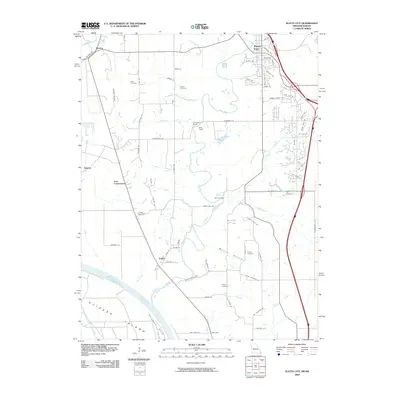
2009 Map of Platte City
USGS Topo · Published 2009About this map
Stigers Island and the Delaware Bend of the Missouri River define the southwestern landscape of this region, where the Platte River meanders toward its confluence. The 2009 survey reveals a rural Missouri landscape marked by established family-named landmarks and small settlements like Farley, Beverly, and East Leavenworth. Significant historical data for genealogists is found in the distribution of local burial grounds, including Todd Cemetery, Brown Cemetery, and Jewett Cemetery, which are scattered throughout the agricultural uplands and near the winding Prairie Creek. Infrastructure such as the Vandahl Airport and river crossings like Humphery Bridge and Detner Bridge illustrate the modern connectivity between these riverside communities and the county seat at Platte City.
Find a feature on this map
89 named features on this map. Tap any name to fly to it.
Don’t see what you’re looking for? This feature index may not catch every label — zoom into the map to look around manually.
Map Details
Editions of this 2009 Platte City Map
This is the sole edition of this map. No revisions or reprints were ever made.
Other maps of this area

1890 · Kansas City
USGS Topo · 1:125,000

1894 · Kansas City
USGS Topo · 1:125,000

1910 · Leavenworth
USGS Topo · 1:62,500

1914 · Smithville
USGS Topo · 1:62,500

1934 · Bonner Springs
USGS Topo · 1:48,000

1934 · Wolcott
USGS Topo · 1:24,000

1940 · Bonner Springs
USGS Topo · 1:62,500
1943 · Quindaro
USGS Topo · 1:31,680
1948 · Wolcott
USGS Topo · 1:24,000

1948 · Leavenworth
USGS Topo · 1:62,500