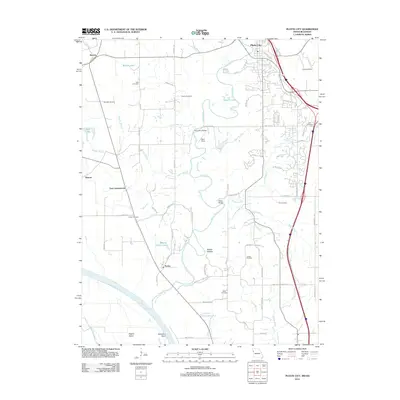
2012 Map of Platte City
USGS Topo · Published 2012About this map
The Missouri River serves as the prominent southwestern boundary for this Platte County region, winding past Delaware Bend and Stigers Island. This landscape is defined by the meandering course of the Platte River, which creates a series of oxbow features including Beverly Lake and Roberts Lake. Small settlements like Farley, Beverly, and East Leavenworth dot the river valley, while Platte City anchors the northeastern corner. For those researching local family history, the map provides precise locations for several rural burial grounds, such as Todd Cemetery, Brown Cemetery, and Green Cemetery. Aviation infrastructure is represented by the Vandahl Airport and a separate Landing Strip, reflecting the modern mix of agriculture and transportation near the river. The numerous creeks, such as Naylor Creek and Prairie Creek, suggest a complex drainage system that has long influenced the development of these bottomlands.
Find a feature on this map
70 named features on this map. Tap any name to fly to it.
Don’t see what you’re looking for? This feature index may not catch every label — zoom into the map to look around manually.
Map Details
Editions of this 2012 Platte City Map
This is the sole edition of this map. No revisions or reprints were ever made.
Other maps of this area

1890 · Kansas City
USGS Topo · 1:125,000

1894 · Kansas City
USGS Topo · 1:125,000

1910 · Leavenworth
USGS Topo · 1:62,500

1914 · Smithville
USGS Topo · 1:62,500

1934 · Bonner Springs
USGS Topo · 1:48,000

1934 · Wolcott
USGS Topo · 1:24,000

1940 · Bonner Springs
USGS Topo · 1:62,500
1943 · Quindaro
USGS Topo · 1:31,680
1948 · Wolcott
USGS Topo · 1:24,000

1948 · Leavenworth
USGS Topo · 1:62,500