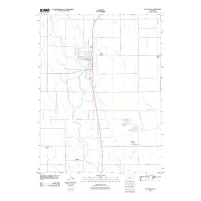
2010 Map of Platteville
USGS Topo · Published 2010About this map
The South Platte River winds through this Colorado landscape, defining a corridor of agricultural activity and irrigation infrastructure. The town of Platteville serves as the central hub, supported by a dense network of water management features including the Spear Canal, Platte Valley DITCH, and Bucker Ditch. This reliance on water rights and engineering is further evidenced by several named reservoirs and dams, such as Twombly Reservoir and Mose Davis Lake, which anchor the eastern portion of the quadrangle. Smaller settlements like Vollmar, Ione, and Maddux appear along the transportation routes, reflecting the region's rural development patterns. Local history is documented through sites like Mizpah Cemetery and Saint Francis Cemetery, while the presence of the Kugel-Strong Airport highlights the mix of traditional land use and modern infrastructure in Weld County during this period.
Find a feature on this map
52 named features on this map. Tap any name to fly to it.
Don’t see what you’re looking for? This feature index may not catch every label — zoom into the map to look around manually.
Map Details
Editions of this 2010 Platteville Map
This is the sole edition of this map. No revisions or reprints were ever made.
Other maps of this area

1902 · Greeley
USGS Topo · 1:125,000

1949 · Gowanda
USGS Topo · 1:24,000

1949 · Fort Lupton
USGS Topo · 1:24,000

1949 · Platteville
USGS Topo · 1:24,000

1949 · Hudson
USGS Topo · 1:24,000

1950 · Frederick
USGS Topo · 1:24,000

1950 · Gowanda
USGS Topo · 1:24,000

1950 · Platteville
USGS Topo · 1:24,000
1950 · Fort Lupton
USGS Topo · 1:24,000

1950 · Johnstown
USGS Topo · 1:24,000