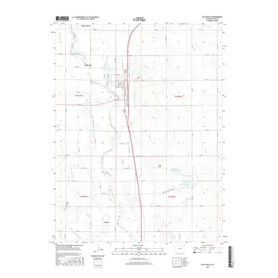
2016 Map of Platteville
USGS Topo · Published 2016About this map
Platteville and Milliken anchor this 2016 study of the agricultural corridor north of Denver, where the South Platte River dictates the landscape's complex irrigation network. This high-plains region is defined by an intricate system of man-made waterways including the Farmers Independent Ditch, Spear Canal, and Platteville Ditch, which redirect water across the section lines to support the surrounding farmland. The map provides significant detail for local history, marking the small settlement of Vollmar and aviation sites like Tonga Airport. Genealogical interest is found at Mizpah Cem and Saint Francis Cem, while larger-scale water management is evident through the Mose Davis Reservoir Number 2 and the Twombly Reservoir. The rigid grid of county roads, such as Co RD 36 and Co RD 34, contrasts with the meandering riverbed, illustrating the long-term intersection of natural hydrology and systematic land development.
Find a feature on this map
66 named features on this map. Tap any name to fly to it.
Don’t see what you’re looking for? This feature index may not catch every label — zoom into the map to look around manually.
Map Details
Editions of this 2016 Platteville Map
This is the sole edition of this map. No revisions or reprints were ever made.
Other maps of this area

1902 · Greeley
USGS Topo · 1:125,000

1949 · Gowanda
USGS Topo · 1:24,000

1949 · Fort Lupton
USGS Topo · 1:24,000

1949 · Platteville
USGS Topo · 1:24,000

1949 · Hudson
USGS Topo · 1:24,000

1950 · Frederick
USGS Topo · 1:24,000

1950 · Gowanda
USGS Topo · 1:24,000

1950 · Platteville
USGS Topo · 1:24,000
1950 · Fort Lupton
USGS Topo · 1:24,000

1950 · Johnstown
USGS Topo · 1:24,000