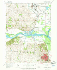
1956 Map of Plattsmouth
USGS Topo · Published 1968About this map
Offutt Air Force Base dominates the northern landscape of this mid-century survey, positioned just above the confluence of the Missouri River and the Platte River. The map details a period of established riverfront settlement and rural education, evidenced by a dense network of country schoolhouses including Trumble Sch, Thiering Sch, and Woodbine Sch. The city of Plattsmouth serves as the focal point in the south, where the Chicago Burlington and Quincy railroad tracks navigate the complex river topography near the Sarpy and Cass County line.
Find a feature on this map
40 named features on this map. Tap any name to fly to it.
Don’t see what you’re looking for? This feature index may not catch every label — zoom into the map to look around manually.
Map Details
Editions of this 1956 Plattsmouth Map
5 editions found

Other maps of this area

1893 · Fremont
USGS Topo · 1:125,000

1896 · Fremont
USGS Topo · 1:125,000

1903 · Weeping Water
USGS Topo · 1:125,000

1929 · Weeping Water
USGS Topo · 1:125,000

1935 · Nehawka
USGS Topo · 1:48,000

1940 · Nehawka
USGS Topo · 1:62,500

1954 · Omaha
USGS Topo · 1:250,000

1955 · Fremont
USGS Topo · 1:250,000

1955 · Nebraska City
USGS Topo · 1:250,000

1955 · Lincoln
USGS Topo · 1:250,000