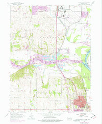
1956 Map of Plattsmouth
USGS Topo · Published 1977About this map
The Missouri River and Platte River converge just north of Plattsmouth, forming a complex riverine landscape of low islands like Cedar Island and expansive floodplains. During the mid-1950s, this area served as a critical nexus for transportation and national defense, anchored by the massive Offutt Air Force Base and a dense network of Burlington Northern railroad lines. The map reveals a transition from the urban expansion of Bellevue in the north to the industrial and residential heart of the county seat to the south.
Find a feature on this map
49 named features on this map. Tap any name to fly to it.
Don’t see what you’re looking for? This feature index may not catch every label — zoom into the map to look around manually.
Map Details
Editions of this 1956 Plattsmouth Map
5 editions found

Other maps of this area

1893 · Fremont
USGS Topo · 1:125,000

1896 · Fremont
USGS Topo · 1:125,000

1903 · Weeping Water
USGS Topo · 1:125,000

1929 · Weeping Water
USGS Topo · 1:125,000

1935 · Nehawka
USGS Topo · 1:48,000

1940 · Nehawka
USGS Topo · 1:62,500

1954 · Omaha
USGS Topo · 1:250,000

1955 · Fremont
USGS Topo · 1:250,000

1955 · Nebraska City
USGS Topo · 1:250,000

1955 · Lincoln
USGS Topo · 1:250,000