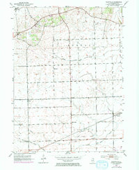
1953 Map of Plattville
USGS Topo · Published 1974About this map
Plattville and the surrounding agricultural townships of Fox, Big Grove, and Lisbon define this prairie landscape as it appeared in the mid-20th century. The map reveals a high density of rural institutions that served the local farming community, including several local schools such as Cross Sch, Plecher Sch, and Lisbon Sch. Small ecclesiastical and genealogical hubs are centered at Emanuel Ch and the adjacent Emanuel Cem, while the settlement of Helmar sits near the crossing of section lines.
Find a feature on this map
20 named features on this map. Tap any name to fly to it.
Don’t see what you’re looking for? This feature index may not catch every label — zoom into the map to look around manually.
Map Details
Editions of this 1953 Plattville Map
2 editions found
Other maps of this area

1892 · Morris
USGS Topo · 1:62,500

1892 · Marseilles
USGS Topo · 1:62,500

1916 · Marseilles
USGS Topo · 1:62,500

1918 · Morris
USGS Topo · 1:62,500

1925 · Yorkville
USGS Topo · 1:62,500

1940 · Marseilles
USGS Topo · 1:62,500

1948 · Sandwich
USGS Topo · 1:62,500

1950 · Sandwich
USGS Topo · 1:62,500

1953 · Plattville
USGS Topo · 1:24,000

1953 · Lisbon
USGS Topo · 1:24,000