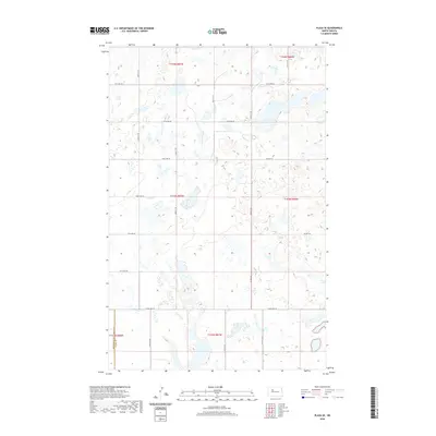
2020 Map of Plaza SE
USGS Topo · Published 2020About this map
Glacial prairie potholes and scattered wetlands define this section of the Missouri Plateau along the Mountrail Co Ward Co boundary. The landscape is organized by a precise grid of section lines and gravel roads, including 121st Ave SW and 205th Ave SW, reflecting the systematic agricultural development of the region. This 2020 survey illustrates how the modern rural infrastructure maintains the township and range divisions established over a century ago. Small, unnamed seasonal ponds are dispersed across the terrain, navigated by local routes such as Co Hwy 16 and Co Hwy 20. The map serves as a clear record of current land management and drainage patterns in a quiet corner of the North Dakota plains, where the open country is punctuated only by the geometric intersections of farm-to-market roads.
Find a feature on this map
16 named features on this map. Tap any name to fly to it.
Don’t see what you’re looking for? This feature index may not catch every label — zoom into the map to look around manually.
Map Details
Editions of this 2020 Plaza SE Map
This is the sole edition of this map. No revisions or reprints were ever made.
Other maps of this area

1954 · Minot
USGS Topo · 1:250,000

1954 · McClusky
USGS Topo · 1:250,000

1958 · McClusky
USGS Topo · 1:250,000

1958 · Minot
USGS Topo · 1:250,000

1980 · Minot
USGS Topo · 1:100,000

1980 · Plaza SE
USGS Topo · 1:24,000

1980 · Makoti
USGS Topo · 1:24,000

1980 · Rice Lake NW
USGS Topo · 1:24,000
1980 · Plaza
USGS Topo · 1:24,000
1980 · Underdahl Lake
USGS Topo · 1:24,000