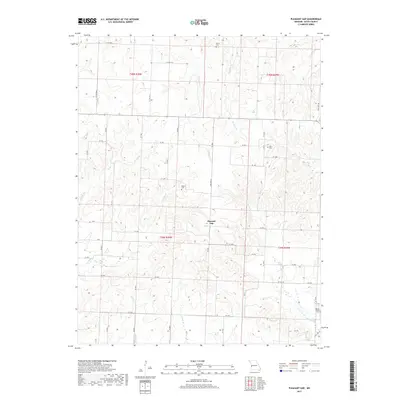
2017 Map of Pleasant Gap
USGS Topo · Published 2017About this map
Pleasant Gap occupies the center of this 2017 Bates County landscape, situated at a junction where the headwaters of numerous creeks begin their descent through the plains. The terrain is defined by a dense network of seasonal streams, including S Deepwater Cr and Straight Br, which carve subtle valleys across the township. For genealogists and local historians, several family-named burial grounds are preserved on the sheet, such as Smith Cem, Rogers Cem, and Myers Cem. The southern edge of the map includes Round Prairie Cem near State Hwy BB. The settlement pattern follows a grid of county roads and state highways like State Hwy O, reflecting a modern agricultural community built upon historic township lines like t39n r30w and t40n r30w. Numerous smaller watercourses like Double Br and Mission Br emphasize the area's complex drainage system within this rural Missouri interior.
Find a feature on this map
56 named features on this map. Tap any name to fly to it.
Don’t see what you’re looking for? This feature index may not catch every label — zoom into the map to look around manually.
Map Details
Editions of this 2017 Pleasant Gap Map
This is the sole edition of this map. No revisions or reprints were ever made.
Other maps of this area

1887 · Butler
USGS Topo · 1:125,000

1894 · Butler
USGS Topo · 1:125,000

1934 · Papinsville
USGS Topo · 1:24,000

1934 · Rockville
USGS Topo · 1:24,000

1936 · Rich Hill
USGS Topo · 1:24,000

1947 · Lawrence
USGS Topo · 1:250,000

1950 · Lawrence
USGS Topo · 1:250,000

1953 · Johnstown
USGS Topo · 1:24,000
1955 · Rich Hill
USGS Topo · 1:24,000

1956 · Lawrence
USGS Topo · 1:250,000