
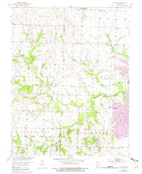
1953 Map of Johnstown
USGS Topo · Published 1954About this map
Deepwater Creek meanders through the heart of this rural Missouri landscape, defining the topography and settlement patterns of southern Henry County. The map captures the agricultural and early industrial character of the early 1950s, where small community hubs like Johnstown and Germantown (Noah) served as local anchors. The transition from traditional farming to extraction is visible near the eastern boundary, where a significant Strip Mine and various Mines appear alongside long-established rural institutions. This survey provides a precise record of the mid-century social geography, documenting the distribution of one-room schools such as White Oak Sch and Aurora Sch, as well as numerous family and community burial grounds including Poage Cem and the Snodgrass Union Cem. The road network connects these scattered points across Sprague Township and Walker Township, following the section lines and natural drainage of Soap Creek and Granddaddy Creek.
Find a feature on this map
30 named features on this map. Tap any name to fly to it.
Don’t see what you’re looking for? This feature index may not catch every label — zoom into the map to look around manually.
Map Details
Editions of this 1953 Johnstown Map
2 editions found
Other maps of this area

1887 · Clinton
USGS Topo · 1:125,000

1887 · Butler
USGS Topo · 1:125,000

1894 · Butler
USGS Topo · 1:125,000

1894 · Clinton
USGS Topo · 1:125,000

1947 · Jefferson City
USGS Topo · 1:250,000

1947 · Lawrence
USGS Topo · 1:250,000

1950 · Lawrence
USGS Topo · 1:250,000

1953 · Montrose
USGS Topo · 1:24,000

1953 · Hartwell
USGS Topo · 1:24,000
1953 · Creighton
USGS Topo · 1:24,000