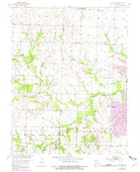
1953 Map of Johnstown
USGS Topo · Published 1982About this map
Deepwater Creek and its many tributaries, including the North Branch and Elm Branch, dominate this landscape on the Bates and Henry County line. In the mid-20th century, the area maintained a rural network of small communities such as Johnstown and Germantown (Noah), the latter featuring the St Ludger Cem. Education and faith were centered around local landmarks like White Oak Sch, Aurora Sch, and the Pleasant Home Ch. Industrial activity is evident in the eastern portion of the quadrangle, where a large Strip Mine and the M-K-T railroad line signify the region's connection to the broader coal and transport economy. For genealogists, the map preserves the locations of numerous family and community burial grounds, from the Poage Cem in the north to the Montrose Cem and Snowgrass Union Cem further south.
Find a feature on this map
34 named features on this map. Tap any name to fly to it.
Don’t see what you’re looking for? This feature index may not catch every label — zoom into the map to look around manually.
Map Details
Editions of this 1953 Johnstown Map
2 editions found
Other maps of this area

1887 · Clinton
USGS Topo · 1:125,000

1887 · Butler
USGS Topo · 1:125,000

1894 · Butler
USGS Topo · 1:125,000

1894 · Clinton
USGS Topo · 1:125,000

1947 · Jefferson City
USGS Topo · 1:250,000

1947 · Lawrence
USGS Topo · 1:250,000

1950 · Lawrence
USGS Topo · 1:250,000

1953 · Johnstown
USGS Topo · 1:24,000

1953 · Montrose
USGS Topo · 1:24,000

1953 · Hartwell
USGS Topo · 1:24,000