
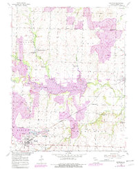
1953 Map of Montrose
USGS Topo · Published 1955About this map
Montrose serves as the primary hub in this Missouri River Basin landscape, situated where the Missouri Kansas Texas railroad cuts through the southern prairies. The mid-century economy is clearly divided between agriculture and extractive industry, with significant Strip Mines and the Morris Mine operating just west and south of the town center. The rural character of Henry County is defined by a dense network of one-room schoolhouses and community churches, including Cleveland Sch, Mound Sch, and Stones Chapel. Deep meandering waterways like Deepwater Creek and Bear Creek create natural breaks in the grid of section lines, often flanked by wooded bottomlands. For genealogists, the map preserves the exact locations of several small burial grounds and parish centers, such as St Ludgers Cem and the Hopewell-Cumberland Ch, providing a detailed look at the social fabric before later consolidation.
Find a feature on this map
37 named features on this map. Tap any name to fly to it.
Don’t see what you’re looking for? This feature index may not catch every label — zoom into the map to look around manually.
Map Details
Editions of this 1953 Montrose Map
2 editions found
Other maps of this area

1887 · Clinton
USGS Topo · 1:125,000

1887 · Butler
USGS Topo · 1:125,000

1894 · Butler
USGS Topo · 1:125,000

1894 · Clinton
USGS Topo · 1:125,000

1947 · Jefferson City
USGS Topo · 1:250,000

1947 · Lawrence
USGS Topo · 1:250,000

1950 · Lawrence
USGS Topo · 1:250,000

1953 · Johnstown
USGS Topo · 1:24,000

1953 · Hartwell
USGS Topo · 1:24,000
1953 · Creighton
USGS Topo · 1:24,000