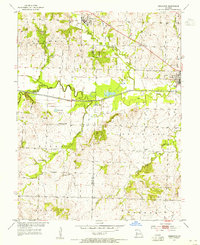
1953 Map of Creighton
USGS Topo · Published 1955About this map
Creighton and Urich anchor the northern reaches of this mid-century landscape, positioned at the convergence of Cass, Henry, and Bates counties. The central geography is dominated by the sprawling floodplain of the Old Channel South Grand River, a complex hydraulic system of oxbows and sloughs including Clear Lake and Sprig Lake. This rural Missouri region in the 1950s was defined by small, decentralized community nodes, many of which are identified by their local institutions. Genealogists and historians will find significant value in the mapped locations of country schools like Smoky Row Sch and Hackley Sch, alongside rural churches such as Cove Creek Ch. The network of small family or community burial grounds, including Parker Cem, Kepler Cem, and Reese Cem, provides a precise geographic record of the families who settled these townships.
Find a feature on this map
32 named features on this map. Tap any name to fly to it.
Don’t see what you’re looking for? This feature index may not catch every label — zoom into the map to look around manually.
Map Details
Editions of this 1953 Creighton Map
This is the sole edition of this map. No revisions or reprints were ever made.
Other maps of this area

1885 · Warrensburg
USGS Topo · 1:125,000

1887 · Clinton
USGS Topo · 1:125,000

1887 · Harrisonville
USGS Topo · 1:125,000

1887 · Butler
USGS Topo · 1:125,000

1887 · Warrensburg
USGS Topo · 1:125,000

1892 · Harrisonville
USGS Topo · 1:125,000

1894 · Harrisonville
USGS Topo · 1:125,000

1894 · Butler
USGS Topo · 1:125,000

1894 · Warrensburg
USGS Topo · 1:125,000

1894 · Clinton
USGS Topo · 1:125,000