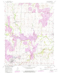
1953 Map of Montrose
USGS Topo · Published 1982About this map
Montrose sits at a critical junction of the Missouri Kansas Texas railroad and the extensive Deepwater Creek drainage system in Henry County. The landscape is defined by its industrial and agricultural balance, featuring numerous coal extraction sites such as the Morris Mine and several Strip Mines. The 1980s-era revisions, shown in purple, highlight the significant presence of Montrose Lake and the Montrose State Wildlife Area, reflecting the area's transformation for water management and conservation.
Find a feature on this map
36 named features on this map. Tap any name to fly to it.
Don’t see what you’re looking for? This feature index may not catch every label — zoom into the map to look around manually.
Map Details
Editions of this 1953 Montrose Map
2 editions found
Other maps of this area

1887 · Clinton
USGS Topo · 1:125,000

1887 · Butler
USGS Topo · 1:125,000

1894 · Butler
USGS Topo · 1:125,000

1894 · Clinton
USGS Topo · 1:125,000

1947 · Jefferson City
USGS Topo · 1:250,000

1947 · Lawrence
USGS Topo · 1:250,000

1950 · Lawrence
USGS Topo · 1:250,000

1953 · Johnstown
USGS Topo · 1:24,000

1953 · Montrose
USGS Topo · 1:24,000

1953 · Hartwell
USGS Topo · 1:24,000